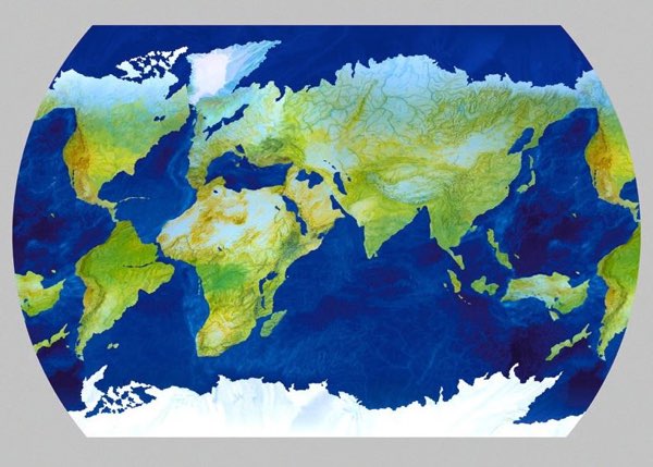
Here is a map, slightly off-kilter but completely recognizable, by Gaicomo Faiella. Can you tell what is special/interesting about it? (Hat tip to Joe Polchinski, and following his lead I won’t reveal the answer in this post — but feel free to leave guesses/spoilers in the comments.)
Comments
29 responses to “Purposeful Distortion”
the northern hemisphere after Arctic Melt ??
It looks like there’s a lot less water on this map than there should be. In fact, exactly half of it seems to be land. 😉
Africa is watching while South America moves away with a big Amazon size grin.
SPOILER!
Isn’t it an M.C. Escher-esque depiction of the world map in which the oceans are secretly identical to the continents, but upside-down?
Kinda-sorta the land and sea are swapped. Blue color is land.
The world as it was many millions of years ago (at a guess, about 50 million years ago, but that could be way out).
@James Marlow
Yes — you’re right. I see it. And the image has to be rotated 180 deg.
Cool! The shapes of the oceans match the shapes of the continents, rotated 180 degrees.
flip the map 180 deg and the land turns into water.
Also, if you click on the image, it will take you to another blog, which has the explanation written down explicitly, so no guessing is necessary. 🙂
Not every blog lets you have as much fun as this one does.
Flip the map upside down and the oceans are now the continents
Africa and Europe are out of place.
It’s a geographical palindrome!
As a geography major heading towards meteorology, these maps fascinate me! The artistry is amazing! Thanks for sharing!
How many people went straight to Google to find out? It’s too easy to cheat. I cheated.
Someone could make a palindrome of Palin droning.
Symmetry:)
You have to look at the land masses in relation to the water?:)
P.s.(edited to say now after reading comments)….made above comment without reading the comments or googling.
It’s pretty good exercise trying to turn the map upside and observe the clever design when you’ve still got your auto-rotate on, on your tablet display!
This is great! Thank you, Sig. Faiella and Dr. Carroll!
(But I don’t believe that one needs to turn the map upside down in order to have a fair shot at discovering its secret.)
Guess before clicking or reading anything else: Doubly inverted. Landwater, Northsouth.
the continents are joined.
The continents and oceans are the same shapes, inverted. The Atlantic Ocean, for example, is an upside-down South America.
The surface and bathymetry features look the same too, just with different color maps.
http://en.wikipedia.org/wiki/Ambigram